

North
Localities in the north of Palencia

Arenillas de San Pelayo
Arenillas de San Pelayo is a town located 80 kilometers north of Palencia in the Valdavia Valley. It belongs to the municipality of Buenavista de la Valdavia and has an approximate population of 60 inhabitants. Its main highlight is the Church of San Pelayo, a Romanesque church that is open to the public from July to October. The town's primary activity is agriculture. Particularly noteworthy is its mushroom industry, which is a pioneer in the province.

San Pedro Neighborhood
Barrio de San Pedro, very close to Aguilar de Campoo.
The small locality of Barrio de San Pedro is located on the left bank of the Aguilar de Campoo reservoir. It is accessed via the road that skirts the reservoir, passing through Quintanilla de la Berzosa and Foldada. It is a population of the Montaña Palentina belonging to Aguilar de Campoo. Today, it is situated 10 kilometers from the biscuit-making town. This seems to give it the tranquility of a small village, but on the other hand, the proximity to a large town that offers all services.
The small locality of Barrio de San Pedro is located on the left bank of the Aguilar de Campoo reservoir. It is accessed via the road that skirts the reservoir, passing through Quintanilla de la Berzosa and Foldada. It is a population of the Montaña Palentina belonging to Aguilar de Campoo. Today, it is situated 10 kilometers from the biscuit-making town. This seems to give it the tranquility of a small village, but on the other hand, the proximity to a large town that offers all services.

Barruelo de Santullán
Barruelo, a Great Mining Past
Barruelo de Santullán. With 1,200 inhabitants today, this village was the most populated in Palencia just a few decades ago. The disappearance of mining, the main activity in the region, caused the population to decrease considerably in just twenty years. Currently, its population is mostly made up of retired miners, and it is increasingly trying to become an emerging tourist destination due to its proximity to the Palencia Mountain.
Barruelo de Santullán. With 1,200 inhabitants today, this village was the most populated in Palencia just a few decades ago. The disappearance of mining, the main activity in the region, caused the population to decrease considerably in just twenty years. Currently, its population is mostly made up of retired miners, and it is increasingly trying to become an emerging tourist destination due to its proximity to the Palencia Mountain.

Bustillo de Santullán
In the Palencia Mountain
Bustillo de Santullán is a small village belonging to Barruelo de Santullán. It is located on the route from Salinas to Barruelo de Santullán. Nestled in a hollow next to Sierra Corisa, it is situated between mountains and near Villanueva de la Torre. It is a group of manor houses with ashlar stone and some of them feature emblazoned coats of arms. Today, it is divided into two parts by the passage of a stream.
Bustillo de Santullán is a small village belonging to Barruelo de Santullán. It is located on the route from Salinas to Barruelo de Santullán. Nestled in a hollow next to Sierra Corisa, it is situated between mountains and near Villanueva de la Torre. It is a group of manor houses with ashlar stone and some of them feature emblazoned coats of arms. Today, it is divided into two parts by the passage of a stream.

Camasobres
Camasobres. On the border with Cantabria.
First of all, Camasobres is a small village in the Palencia mountains. Located near the ascent to Piedrasluengas, it belongs to the Pernía region. Regarding the village, it is worth mentioning that it houses a small parish dedicated to San Pantaleón. This church is also of Romanesque origin and retains its bell gable. It has two stately homes, now converted into hospitality establishments. Finally, its natural surroundings invite you to take a hiking route and visit the Cueva de los Burros, a place once used as a refuge for the region's shepherds. A place of great natural beauty.
First of all, Camasobres is a small village in the Palencia mountains. Located near the ascent to Piedrasluengas, it belongs to the Pernía region. Regarding the village, it is worth mentioning that it houses a small parish dedicated to San Pantaleón. This church is also of Romanesque origin and retains its bell gable. It has two stately homes, now converted into hospitality establishments. Finally, its natural surroundings invite you to take a hiking route and visit the Cueva de los Burros, a place once used as a refuge for the region's shepherds. A place of great natural beauty.

Camporredondo de Alba
Route of the Camporredondo de Alba Reservoirs
Camporredondo de Alba. Located at the foot of the reservoir of the same name, inaugurated by King Alfonso XII in 1930. This locality belongs to the municipality of Velilla del Río Carrión. It is situated on the Route of the Reservoirs, next to the Palencia Mountain. At an altitude of 1250 meters above sea level, it belongs to the Judicial District of Cervera de Pisuerga and has a population of 90 inhabitants. Its main activities are livestock farming and emerging tourism. For dining in Camporredondo, El Abuelo and Tía Goya are both of excellent quality. In the Becerro de las Behetrías (14th century), when discussing the Merindad of Saldaña and its 194 places, Camporredondo is mentioned as a royal domain. There was a palace belonging to the Duke of Frías, lord of the place. According to toponymy, we are in a "coto redondo," a land enclosed by the king, sometimes donated to bishops, monasteries, or magnates for repopulation and exploitation. Researchers note that it was not always a royal domain, as it once belonged, along with its entire district, to Don Íñigo Fernández de Velasco, descendant of the Count of Haro, Constable of Castile, Viceroy of Granada, Lord of Camporredondo, and Duke of Frías. In the Monumental Catalog of the Province of Palencia, the royal decree is mentioned, which exempts the residents of Camporredondo from obligations to the ducal house. There was a monastery from 1196 dedicated to San Martín, later from Aguilar de Campoo. Its ashlar church is dedicated to the Assumption. It has three naves, which is rare in the area, a good rococo main altarpiece with a baroque baptismal font. In the town square, there is an elm over 150 years old, with a diameter of 120 centimeters and a height of 15 meters, included in the Catalog of Plant Specimens of the Natural Spaces Law of Castilla y León for its singular relevance. The Route of the Reservoirs runs through the north of the province of Palencia. It is a route that passes through the region of the Palencia Mountain. Via the P-210 road, the localities of Velilla del Río Carrión and Cervera Pisuerga, along 55 km. Additionally, it is located in the Natural Park of Fuentes Carrionas and Fuente Cobre – Palencia Mountain.
Camporredondo de Alba. Located at the foot of the reservoir of the same name, inaugurated by King Alfonso XII in 1930. This locality belongs to the municipality of Velilla del Río Carrión. It is situated on the Route of the Reservoirs, next to the Palencia Mountain. At an altitude of 1250 meters above sea level, it belongs to the Judicial District of Cervera de Pisuerga and has a population of 90 inhabitants. Its main activities are livestock farming and emerging tourism. For dining in Camporredondo, El Abuelo and Tía Goya are both of excellent quality. In the Becerro de las Behetrías (14th century), when discussing the Merindad of Saldaña and its 194 places, Camporredondo is mentioned as a royal domain. There was a palace belonging to the Duke of Frías, lord of the place. According to toponymy, we are in a "coto redondo," a land enclosed by the king, sometimes donated to bishops, monasteries, or magnates for repopulation and exploitation. Researchers note that it was not always a royal domain, as it once belonged, along with its entire district, to Don Íñigo Fernández de Velasco, descendant of the Count of Haro, Constable of Castile, Viceroy of Granada, Lord of Camporredondo, and Duke of Frías. In the Monumental Catalog of the Province of Palencia, the royal decree is mentioned, which exempts the residents of Camporredondo from obligations to the ducal house. There was a monastery from 1196 dedicated to San Martín, later from Aguilar de Campoo. Its ashlar church is dedicated to the Assumption. It has three naves, which is rare in the area, a good rococo main altarpiece with a baroque baptismal font. In the town square, there is an elm over 150 years old, with a diameter of 120 centimeters and a height of 15 meters, included in the Catalog of Plant Specimens of the Natural Spaces Law of Castilla y León for its singular relevance. The Route of the Reservoirs runs through the north of the province of Palencia. It is a route that passes through the region of the Palencia Mountain. Via the P-210 road, the localities of Velilla del Río Carrión and Cervera Pisuerga, along 55 km. Additionally, it is located in the Natural Park of Fuentes Carrionas and Fuente Cobre – Palencia Mountain.

Canduela
This locality is situated to the north of Palencia in the Montaña Palentina region. Within the Montaña Palentina, it is on the border with Cantabria. Currently, it is a hamlet of the municipality of Aguilar de Campoo. It is located 7 kilometers from Aguilar de Campoo. Additionally, it is well connected by the nearby Meseta Highway to Cantabria. It has about 30 inhabitants.

Cantoral de la Peña
Cantoral de la Peña. A village in the Montaña Palentina located 110 kilometers from Palencia. Firstly, and most notably, it is very close to Cervera de Pisuerga, which is the most significant hub in the area. Cantoral de la Peña is a locality within the municipality of Castrejón de la Peña in the province of Palencia. It is part of the Jacobean route that connected San Vicente de la Barquera with Carrión de los Condes via the Camino Real de la Valdavia. The church of Santa Ana stands out, featuring a Romanesque entrance door. The layout of the temple is distributed in a single nave, which preserves a Baroque altar with Solomonic columns and a Romanesque baptismal font from the 12th century. It depicts various scenes, including a knight fighting a dragon, several priestly figures, and two other monsters. The cultural offerings are complemented by a series of routes and excursions through the Valle de Tosande, highlighting the Tejeda de Tosande, a spectacular yew forest unique in size in Europe. It is a natural site of great beauty, belonging to the Montaña Palentina Natural Park.

Castrejón de la Peña
Castrejón de la Peña is a municipality located in the north of the province of Palencia. It belongs to the region of Montaña Palentina. It is situated at the foothills of the Sierra de la Peña. With 300 inhabitants, it lies at the base of the Sierra del Brezo. It is approximately 106 kilometers from Palencia. The traditional wealth of the region was the coal mining activity and its quarries. The La Robla railway connected all these places until its closure. To visit all these lands, you can follow the C-626 road that runs from east to west, a section of the reservoir route between Cervera and Guardo. The Cerro de la Penilla
Its ancient fortress is located at the foot of the Cerro de La Penilla, situated to the north of the town. A small platform currently bears witness to the primitive fort that gave the town its name. Inhabited since the Bronze Age. In the 1st and 2nd centuries, there was a Roman settlement in Cantoral de la Peña. The Roman road that connected Salcedillo with Cervera and Guardo passed through here. Castrejón de la Peña was one of the first areas to be repopulated. The town of Castrejón was always the head of a small merindad or community of land, within the Merindad of Saldaña. It maintained its royal status until the 14th century, when it came under the control of various lords. Testimonies of this era are the ruins of the Castle and the medieval Necropolis in La Penilla. In Castrejón de la Peña, the church of Santa Águeda stands out, located in its urban area. It is a transitional building from the Gothic to the Renaissance style. With a façade featuring a depressed arch enhanced by another ogee arch. Inside, it houses a restored 17th-century Christ. From Castrejón de La Peña, it is worth visiting the municipality of Pisón de Castrejón to admire the church of La Anunciación.
STAY IN CASTREJÓN DE LA PEÑA
Its ancient fortress is located at the foot of the Cerro de La Penilla, situated to the north of the town. A small platform currently bears witness to the primitive fort that gave the town its name. Inhabited since the Bronze Age. In the 1st and 2nd centuries, there was a Roman settlement in Cantoral de la Peña. The Roman road that connected Salcedillo with Cervera and Guardo passed through here. Castrejón de la Peña was one of the first areas to be repopulated. The town of Castrejón was always the head of a small merindad or community of land, within the Merindad of Saldaña. It maintained its royal status until the 14th century, when it came under the control of various lords. Testimonies of this era are the ruins of the Castle and the medieval Necropolis in La Penilla. In Castrejón de la Peña, the church of Santa Águeda stands out, located in its urban area. It is a transitional building from the Gothic to the Renaissance style. With a façade featuring a depressed arch enhanced by another ogee arch. Inside, it houses a restored 17th-century Christ. From Castrejón de La Peña, it is worth visiting the municipality of Pisón de Castrejón to admire the church of La Anunciación.
STAY IN CASTREJÓN DE LA PEÑA

Cervera de Pisuerga
The Capital of the Palencia Mountain
Cervera de Pisuerga, the heart of the Palencia mountain, is located within the Palencia Mountain Natural Park. It boasts significant sites of interest such as the Church of Santa María del Castillo and the rock-hewn hermitage of San Vicente. It offers an unparalleled natural environment and serves as a starting point for mountain getaways to visit the Roblón de Estalaya, the Tejada de Tosande, or the Fossil Forest. Additionally, it provides visitors with the Park House to seek information about this great natural space.
The Roman Cervaria
The Roman Cervaria, land of deer. Situated in a privileged location due to its proximity to tourist attractions. As an administrative, commercial, social, health, communication, and relationship center, it is a beautiful and lively small town that thrives significantly on services, as much or more than on other agricultural, livestock, or forestry activities.
Cervera de Pisuerga, the heart of the Palencia mountain, is located within the Palencia Mountain Natural Park. It boasts significant sites of interest such as the Church of Santa María del Castillo and the rock-hewn hermitage of San Vicente. It offers an unparalleled natural environment and serves as a starting point for mountain getaways to visit the Roblón de Estalaya, the Tejada de Tosande, or the Fossil Forest. Additionally, it provides visitors with the Park House to seek information about this great natural space.
The Roman Cervaria
The Roman Cervaria, land of deer. Situated in a privileged location due to its proximity to tourist attractions. As an administrative, commercial, social, health, communication, and relationship center, it is a beautiful and lively small town that thrives significantly on services, as much or more than on other agricultural, livestock, or forestry activities.

Cordovilla de Aguilar
Cordovilla de Aguilar is a small village in the north of Palencia with barely 7 inhabitants. Located near Aguilar de Campoo, just ten minutes from Cordovilla de Aguilar, it is 105 kilometers from Palencia. Surrounded by oak forests, it is a peaceful place to enjoy rural tourism. Cordovilla de Aguilar is a hamlet of the municipality of Aguilar de Campoo in the province of Palencia. According to its toponymy, it may mean "the little Córdoba of Aguilar." It seems to have arisen as a result of the flight of the Mozarabic population from the Cordoban lands due to the Moorish invasion. The Church of Cordovilla is dedicated to Santa María, is of Romanesque style, and dates back to the 12th century. It is located in the center of the village and has been recently restored. It has a single nave, adorned with a simple belfry. From its original Romanesque period, it retains its simple apsidal head and a simple triumphal arch. Inside the temple, we can admire its Solomonic Baroque altarpiece, at the center of which is enthroned an 18th-century Immaculate Conception. It was declared a Cultural Heritage Site in 1966.
Save
Header of the Northwest Zone.
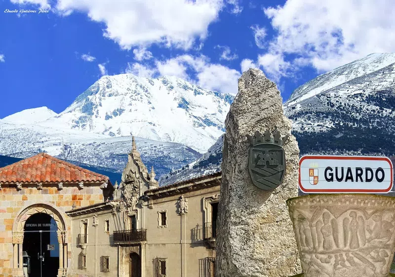
Guardo is a town located in the north of the province, serving as the gateway to the Route of the Reservoirs and also to the province of León. Once the mining hub of the area, today it primarily hosts the most important commercial activity in the region. It is also known for its live Passion play during Holy Week and its unique moving Nativity scene at Christmas. It is to the upper Carrión what Cervera is to the upper Pisuerga. A gateway, inn, market, services, and leisure. Unlike Cervera, it does not possess archaeological riches comparable to those of Aguilar or the small villages in its own region. It is essential to mention the Palace of Bishop Bullón or the Casa Grande of Guardo, from the 18th century, with a style between Plateresque and Baroque, beautifully designed. There are a few other emblazoned houses because, apart from the castle ruins, there is the hermitage of Cristo del Amparo, with a good belfry. The 17th-century parish church and the modern monument to the miner do not have much to show a visitor who comes from exploring astonishing itineraries.
Guardo is, above all, a town with aspirations of being a modern city. With a diversified economy (services, livestock, agriculture, forest wealth, mines, and thermal and chemical industry). Without dismissing the part it can play in tourism, as the head of a zone with great attractions for visitors. It has welcomed a large part of the emigration from the region (which accounts for 75% of the population compared to 1945). It continues to grow within an open valley of the Carrión. We descend a steep slope on the road coming from Saldaña. A plateau reforested in sections with dense pine forests. From Guardo onwards, all inhabited centers are located along the Carrión or the reservoirs of Compuerto and Camporredondo, which have occupied a large part of the most fertile meadows in the area, creating wealth at the cost of contributing to depopulation.
Guardo is a town located in the north of the province, serving as the gateway to the Route of the Reservoirs and also to the province of León. Once the mining hub of the area, today it primarily hosts the most important commercial activity in the region. It is also known for its live Passion play during Holy Week and its unique moving Nativity scene at Christmas. It is to the upper Carrión what Cervera is to the upper Pisuerga. A gateway, inn, market, services, and leisure. Unlike Cervera, it does not possess archaeological riches comparable to those of Aguilar or the small villages in its own region. It is essential to mention the Palace of Bishop Bullón or the Casa Grande of Guardo, from the 18th century, with a style between Plateresque and Baroque, beautifully designed. There are a few other emblazoned houses because, apart from the castle ruins, there is the hermitage of Cristo del Amparo, with a good belfry. The 17th-century parish church and the modern monument to the miner do not have much to show a visitor who comes from exploring astonishing itineraries.
Guardo is, above all, a town with aspirations of being a modern city. With a diversified economy (services, livestock, agriculture, forest wealth, mines, and thermal and chemical industry). Without dismissing the part it can play in tourism, as the head of a zone with great attractions for visitors. It has welcomed a large part of the emigration from the region (which accounts for 75% of the population compared to 1945). It continues to grow within an open valley of the Carrión. We descend a steep slope on the road coming from Saldaña. A plateau reforested in sections with dense pine forests. From Guardo onwards, all inhabited centers are located along the Carrión or the reservoirs of Compuerto and Camporredondo, which have occupied a large part of the most fertile meadows in the area, creating wealth at the cost of contributing to depopulation.

Herrera de Pisuerga
The ancient Pisoraca camp is now Herrera de Pisuerga
A locality in the Palencia region of Boedo-Ojeda, located 80 km from the provincial capital. This town is situated near the Pisuerga River and the Canal de Castilla, the largest hydraulic engineering work of the 18th century in Spain. It hosts important places of interest such as the Archaeological Classroom to better understand the Roman world. You can sail on the Marqués de la Ensenada along the Canal de Castilla. This locality invites you to its festivals, such as the Exaltation of the River Crab. It is celebrated on the first weekend of August, featuring a parade of floats. As a lordship of the constables, it participated in the War of the Communities on the Emperor's side. At the beginning of the 20th century, María Cristina granted Herrera the title of city, which it fulfills very gallantly. Herrera, a city of passage, will always be a welcoming place for visitors.
A locality in the Palencia region of Boedo-Ojeda, located 80 km from the provincial capital. This town is situated near the Pisuerga River and the Canal de Castilla, the largest hydraulic engineering work of the 18th century in Spain. It hosts important places of interest such as the Archaeological Classroom to better understand the Roman world. You can sail on the Marqués de la Ensenada along the Canal de Castilla. This locality invites you to its festivals, such as the Exaltation of the River Crab. It is celebrated on the first weekend of August, featuring a parade of floats. As a lordship of the constables, it participated in the War of the Communities on the Emperor's side. At the beginning of the 20th century, María Cristina granted Herrera the title of city, which it fulfills very gallantly. Herrera, a city of passage, will always be a welcoming place for visitors.

Matalbaniega
Matalbaniega. A locality whose origin dates back to the first settlers from Liébana in Cantabria. Since its medieval origins, its economy has been primarily based on livestock. It has only 6 inhabitants and is also located in the Montaña Palentina, boasting a first-rate Romanesque heritage with its Church of San Martín, one of the finest examples of Northern Romanesque architecture.

Mave
Belonging to Aguilar de Campoo, it has a population of 71 inhabitants. Located within the Montaña Palentina, it is a very touristic area due to its artistic heritage and natural beauty. The Las Tuerces Natural Space, the Cañón de la Horadada, and the Monastery of Santa Maria de Mave in the vicinity are important attractions. It offers rural accommodations and dining options.

Montoto de Ojeda
Montoto de Ojeda between Olmos de Ojeda and Perazancas
Montoto de Ojeda is a locality with 10 inhabitants, integrated into Vega de Bur. In Montoto de Ojeda, the Church of San Esteban stands out, belonging to the 12th-century Romanesque style and also a notable element of the Palencia Romanesque. The corbels surrounding the apse are particularly noteworthy.
Montoto de Ojeda is a locality with 10 inhabitants, integrated into Vega de Bur. In Montoto de Ojeda, the Church of San Esteban stands out, belonging to the 12th-century Romanesque style and also a notable element of the Palencia Romanesque. The corbels surrounding the apse are particularly noteworthy.

Mudá
Ideal Location, Ideal Romanesque Church. Mudá.
Mudá is a small village with just about a hundred residents, located in the northern part of the province. It is close to Cervera de Pisuerga, in the surroundings of the Palencia Mountain. Particularly noteworthy is the visitor's opportunity to see the Church of San Martín or the Hermitage of Oterillo. It is also one of the clearest examples of Palencia Romanesque architecture in the area.
Mudá is a small village with just about a hundred residents, located in the northern part of the province. It is close to Cervera de Pisuerga, in the surroundings of the Palencia Mountain. Particularly noteworthy is the visitor's opportunity to see the Church of San Martín or the Hermitage of Oterillo. It is also one of the clearest examples of Palencia Romanesque architecture in the area.

Nava de Santullán
Nava de Santullán is one of the hamlets of Barruelo de Santullán, located five kilometers away, in the Montaña Palentina. With barely 20 inhabitants, it is near the Santuario del Carmen. Pilgrimages are also held here, and accommodation and dining services are offered.

Nestar
Nestar is 6 kilometers from Aguilar de Campoo. It has 45 inhabitants and is known for its bridge, Roman road, and cheese factory. Ideal for relaxation, it also benefits from the proximity of all the services in Aguilar de Campoo.

Olleros de Pisuerga
Olleros de Pisuerga, part of Aguilar de Campoo, is a small village with 45 inhabitants. It is globally renowned for its rock-cut church of Saints Justo and Pastor. Originating in the 7th century, it is the best-preserved example in Spain among hermitages carved into rock. It has been fully restored and is located near the Cañón de la Horadada and the Castro de Monte Cildá. Olleros is a tiny village with barely 50 inhabitants, situated 7 km from Aguilar. It boasts a true marvel: one of the largest (14 x 7 meters) and best-preserved rock-cut churches in Spain, carved into sandstone. The two-nave, rectangular body was sculpted in the 10th century. In the sandstone rock, not only were both naves hollowed out, but the arches dividing them were also crafted, along with the false pointed barrel vaults covering them (supported by three strong columns of different types), the transverse arches, and the two shell-shaped apses, possibly added later, at least in their current form. Subsequently, two more rooms have been excavated, one serving as a sacristy with access to the pulpit and another to house the baptismal font.

Olmos de Ojeda
Olmos de Ojeda. Located in the Boedo-Ojeda region in the north of the province of Palencia, it has a population of 50 inhabitants. It is known for being home to the Church of Santa Eufemia de Cozollos or Collozos. This Romanesque gem is one of the purest buildings that can be found in the entire province. Its state of conservation is excellent.
Palencia, the great unknown.
Palencia, the great unknown.

Polentinos
Polentinos. Very close to Cervera de Pisuerga and San Salvador de Cantamuda. It is 125 kilometers away from Palencia and has a population of 50 inhabitants. It is also a short distance from the Montaña Palentina Natural Park. Nearby is the Requejada Reservoir, one of those that make up the famous Route of the Reservoirs.

Prádanos de Ojeda
Prádanos de Ojeda is a small town located in the north of Palencia, very close to Alar del Rey. We highlight its parish church of Romanesque origin but completed in the 16th century. Its hermitage of San Pedro, located in the town square, is also of special significance.

Quintanilla de las Torres
Quintanilla de las Torres is a small hamlet currently belonging to the Municipality of Pomar de Valdivia. It is located in the northeast of the province, very close to the A-67 highway and Aguilar de Campoo. Its origins date back to Roman times. In the past, it was an important railway and communications hub. Today, it is a peaceful village from which we can access the Palencia mountain range and the Las Loras Geopark. This Geopark is the first in Castilla y León to be declared a UNESCO Global Geopark.

Renedo de Zalima
Renedo de Zalima. A hamlet of Salinas de Pisuerga with 7 inhabitants, located within the Montaña Palentina. It features several stone masonry constructions such as La Casona and the Church of San Román. Its name is derived from the large number of frogs that used to inhabit the area. Zalima is a Mozarabic proper name of the owner of this territory, which belonged to the Court of Castile. The village has a rural hotel with four rooms.

Roscales de la Peña
Roscales de la Peña. 98 kilometers from Palencia and with about 50 inhabitants, it is very close to the Sierra del Brezo and therefore to the Montaña Palentina. It is a mushroom-picking area where you can also enjoy hunting, fishing, and paragliding. During the autumn season, between the months of September and October, it is common to enjoy the deer rut.

Ruesga
Ruesga. It is a hamlet of Cervera de Pisuerga, located just about five kilometers away. It has approximately 45 inhabitants and is known for its reservoir. It is a hub for tourism activities such as dining and accommodation, as well as water activities. It is one of the two official swimming areas in the province, along with the Aguilar de Campoo Reservoir.

Salinas de Pisuerga
Salinas de Pisuerga is located in the Montaña Palentina. This town, with approximately 320 inhabitants, is an ideal place for fishing. It offers various services, including a FEVE station, a geriatric residence, a pharmacy, a supermarket, a butcher shop, a hair salon, a bar, a café, a restaurant, and also a Civil Guard station. Particularly noteworthy are its rural accommodations, one of which is a renovated mill with excellent facilities. It is 111 kilometers away from the capital of Palencia. Additionally, it boasts beautiful scenery throughout the area, at the foot of Peñalabra. It is also situated on the banks of the Pisuerga River.

San Martín de los Herreros
San Martín de los Herreros is a small village in the municipality of Cervera de Pisuerga with barely 10 inhabitants. It is located 10 kilometers from Cervera de Pisuerga. This charming village can be accessed from the road that circles the Route of the Reservoirs. Primarily a livestock and agricultural community, it is also known for the legend of the Giant of the Narrow Valley. According to the legend, the Giant lived in this village with his daughter, who, upon reaching adolescence, left her father to live far away. The Giant, overwhelmed with sadness, climbed to Peña Redonda for several months to see if he could spot her. There, death surprised him, and as the legend goes, he was petrified on the mountain, where today we can see his silhouette lying on the mountain.

San Martín de Perapertú
A population of 30 inhabitants in the heart of the Montaña Palentina. Belonging to the Municipality of San Cebrian de Mudá. This is one of the most isolated and naturally beautiful areas in the region. It is also common to see cows and horses grazing in its meadows, providing a rather picturesque view of the Valley.

Santa María de Mave
Santa María de Mave. Located in the foothills of the Montaña Palentina and very close to Aguilar de Campoo, the municipality to which it belongs. It has barely 25 inhabitants. Dating back to the Middle Ages, this village is known for its Benedictine Monastery. This gem, a must-visit for anyone traveling through the area, features a fascinating Inn run by Begoña Moral and a restaurant managed by her brother Nacho Moral, a student of the Juan Mari Arzak school.

Santa María de Nava
It is a small village belonging to Barruelo de Santullán with barely 15 inhabitants. Known for its El Carmen Sanctuary. It offers visitors a beautiful landscape of the Palencia Mountain. From the sanctuary's viewpoint, which also has a restaurant and rooms, you can enjoy the scenery. In the vicinity of the viewpoint, we can observe the Ursi route. There is a group of tables and benches for resting and eating.

Santa María de Redondo
Santa María de Redondo is a small village in the Montaña Palentina with barely 30 inhabitants. It belongs to the Comarca de la Pernía. Its activities are related to livestock farming, agriculture, and rural tourism. It is located in the southern area of the Sierra de Híjar and also offers fantastic landscapes.

Santibáñez de la Peña
Santibáñez de la Peña is a locality located in the north of the province, 106 kilometers from the capital and 6 kilometers from Guardo. Visitors can explore the Castro de la Loma, a large excavation of a Cantabrian fort. Additionally, the ruins of the Monastery of San Román de Entrepeñas are also visitable. The area offers a gas station, supermarket, shop, bakeries, sweet and sausage factories, a place to eat, and three cafés. It is situated at the foot of the Sierra del Brezo in the Palencia Mountain range.

Tarilonte de la Peña
It is a village in the north of the province at the foot of the Sierra del Brezo. With just 40 inhabitants, it has a rural house and a small rural hotel. Located on the Camino Olvidado, which also leads to Santiago de Compostela. It offers easy access to the mountains and moorland trails, where activities on foot and motorized activities are carried out.

Triollo
It is located at the tail of the Camporredondo Reservoir, at an altitude of 1,299 meters above sea level. It is 22 kilometers from Cervera de Pisuerga, 37 kilometers from Guardo, and 134 kilometers from Palencia. It serves as the gateway to the nearby town of Vidrieros. There are no shops, so it is supplied by traveling vendors. Accommodation is available in a hostel with 16 rooms and a bar-restaurant.

Valberzoso
Valberzoso is a village with approximately 20 inhabitants, featuring rural accommodations and several nearby nature trails. The village is divided into two parts or neighborhoods. In the neighborhood known as the upper one, we find an oak tree over 500 years old, next to a table with benches for dining in the shade. It is unique in its kind throughout the area. Highly recommended are visits to the Roman bridge of Rojadillo and its fisherman's path, as well as the Ujapero beech forest. This spectacular forest mass is especially striking in autumn. It hides the refuge of the well-known Civil War maquis, Tonino Cardero.
Boedo de Castrejón
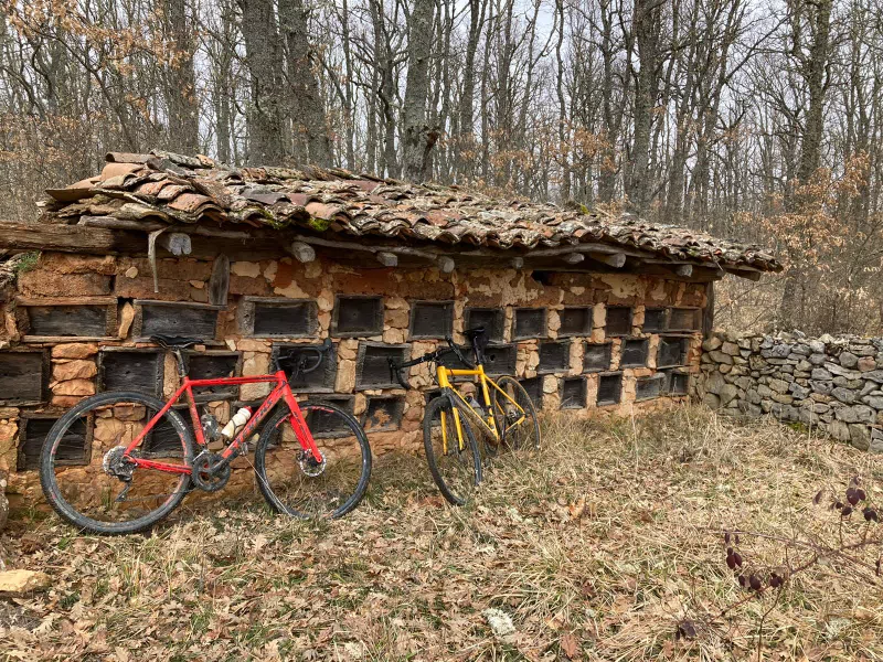
It is a unique case in Palencia. Despite its more than 900 years of documented history, it has barely evolved in terms of urban planning and population. In the 19th century, it had three houses, and today it does not exceed five, maintaining its original structure and essence intact over time. Its resistance to growth and its ability to endure without major transformations have earned it the comparison to "The Village of Asterix and Obelix of Palencia," a hamlet that resists disappearing. Read more.

Valdegama
Valdegama is a village that belongs to the Municipality of Aguilar de Campoo. It is located 10 kilometers from Aguilar de Campoo and within the Palencia Mountain range, with a population of just 5 inhabitants. Founded in the Middle Ages, it is particularly notable for having been part of the Merindad Menor of Aguilar de Campoo. Situated at 926 meters above sea level, it also has several caves in its vicinity. It is worth mentioning that some of these caves have entrances and exits that traverse the mountain.

Vallespinoso de Cervera
Locality and hamlet located 7 kilometers from Cervera de Pisuerga. It has 24 inhabitants and its industry is mainly beekeeping.

Valoria de Aguilar
Valoria de Aguilar is a hamlet of Aguilar de Campoo. It is located just two kilometers from this town. It currently has about 35 inhabitants. It is included in the Northern Way of the Camino de Santiago. It offers houses with ashlar walls and excellent landscapes.

Velilla del Río Carrión
It was Velilla de Guardo until its prosperity allowed it to emulate its head town. Not long ago, they were 5 km apart, a distance that is shrinking due to the growth of both centers. In Velilla, it is a must to visit the Roman fountain of La Reana. Some identify it with Pliny's Tamáricas fountains. It has the peculiarity of flowing intermittently. It remains dry for a while and suddenly fills with water with a characteristic noise, only to dry up again after some time. This is a phenomenon with a clear natural explanation in a karst terrain. Since ancient times, it has been surrounded by tales and bad omens, which possibly led to the nearby construction of the hermitage of San Juan de las Fuentes Divinas to counteract them. To the arch built by the Romans within the cistern, two modern ones have been added, easily identifiable.
Velilla, like Guardo, is privileged by the installation of the thermal power plant, under whose protection it has prospered, and it has done so with careful attention to the environment, compensating for the inevitable negative impact with good urbanization of the surroundings.
Velilla, like Guardo, is privileged by the installation of the thermal power plant, under whose protection it has prospered, and it has done so with careful attention to the environment, compensating for the inevitable negative impact with good urbanization of the surroundings.

Window
Ventanilla is a hamlet of Cervera de Pisuerga. It is located in the Montaña Palentina. With an approximate population of 40 inhabitants, Ventanilla's historical activity was trade through bartering. It was an old trading post for carters and livestock farmers, exchanging wine and other goods with the populations of Tierra de Campos. Currently, being part of La Ruta de los Pantanos, it is a place of passage and offers dining and accommodation options. The fishing reserve that bears its name is well-known for its quality and abundance.

Vidrieros
125 kilometers from Palencia, it is located at the foot of the Curavacas peak in the Carrión River Valley. Very close to Triollo and La Lastra, and also near the Camporredondo reservoir. This area was the site of Roman military campaigns against the Cantabrians in the 1st century BC. Traditionally, it has been a community dedicated to agriculture and livestock, and currently, there is also an emerging tourism activity related to nature.

Viduerna de la Peña
Viduerna de la Peña is a small village in the Montaña Palentina, 100 km from the capital, with barely 45 inhabitants and a peculiar history. THE LAST OF THE PHILIPPINES. JESÚS GARCÍA QUIJANO, FROM VIDUERNA Its most illustrious son, Jesús García Quijano, enlisted in the Spanish Army in 1898. That year, a civil uprising occurred in the Philippines, which was then occupied by Spain, as was Cuba. He was deployed to the Philippines along with 24,000 other men. Once there, he endured a siege with 55 other men inside a church for 11 months in the town of Baler, which is now twinned with Viduerna.

Villacibio
11 kilometers from Aguilar de Campoo, on the border with the province of Burgos, it has 14 inhabitants. The Hermitage of San Pelayo is of interest, a rock-cut hermitage excavated in the 7th century. Similar hermitages can be found in the Palencia and Burgos area as well as in the south of Cantabria. It is very archaic and features two simple horseshoe arches completely carved into the stone.

Villalba de Guardo
Located in the north of Palencia, just four kilometers from Guardo. It has a population of 190 people, and its main activities are livestock and agriculture. It is well-known among bird lovers due to the curious fact that it hosts more than 60 stork nests, even in the center of the town. The sound of all of them clattering their beaks is a unique spectacle.

Villanueva de Arriba
It is a village near Guardo (4 kilometers away) with approximately 120 inhabitants. Located in the heart of the Palencia Mountain, it offers various nature alternatives. It also has a plateau area with pine forests. A cave with an entrance and exit to the place known as San Pedro. A flat area that offers several forest trails for walking or outdoor activities. The excavation of the Cueva de Guantes, where remains from thousands of years ago have been discovered, including both animal and human remains.
In its mountainous area, several routes lead us to the foothills of the Sierra del Brezo, Fuente Los Mures, Pico del Fraile, or San Román de Entrepeñas. In the village, there is a small bar-shop-tobacconist. It is a quiet place with barely 100 inhabitants.
In its mountainous area, several routes lead us to the foothills of the Sierra del Brezo, Fuente Los Mures, Pico del Fraile, or San Román de Entrepeñas. In the village, there is a small bar-shop-tobacconist. It is a quiet place with barely 100 inhabitants.

Villanueva de la Peña
It is a small village located in the Montaña Palentina. As a hamlet belonging to Castrejón de la Peña, it is situated at the foot of Peña Redonda. With only 18 inhabitants, it has a well-equipped sports area. A spectacular church with a Romanesque-Gothic transitional portal.